THE LOCATION
SIRRL Director Paul Taylor recently told Why Waste Waimate (WWW) that the Waimate District was chosen to build the proposed Waimate waste incinerator as it was central for the sourcing and distribution of waste for the plant, making it the ideal location. Mr Taylor said the next step was to find an appropriate site. He said the Carroll’s Road site was one of three or four options explored by the company. However, Carroll’s Road was chosen because of its proximity to rail and neighbouring industries, which could utilise the plant’s energy. The only neighbouring industry in the area, and therefore the only industry SIRRL could be referring to, is the Oceania Dairy factory. SIRRL has gone as far as to say that neighbouring industry will offset emissions from current coal-fired boilers by using energy produced by the incinerator.
Mr Taylor was recently asked if SIRRL had any agreements with Oceania; his answer was no.
WWW also asked Mr Taylor if SIRRL had any agreements with Kiwirail to rail waste to the site; his answer was no.
SIRRL have stated in their resource consent that the waste will be sourced as follows;
- Canterbury (mainly Christchurch): 71%
- Dunedin: 15%
- Central Otago: 14%
With 71% of the waste coming from mainly Christchurch and no agreements with Oceania or Kiwirail, this begs the question: why Waimate? SIRRL director Paul Taylor claimed Waimate was chosen because it was the “Perfect location.” However, Waimate is not Renew Energy, China Tianying, or even Mr Taylor’s first rodeo. Failed proposals in Westport and Hokitika show Waimate to be, at best, third in line.
THE CHOSEN SITE
The site chosen for the incinerator is a 14.85 hectare area of farmland on the corner of Carroll’s Road and Morven/Glenavy Road. The site is approximately 2.5 km from a school within the Glenavy township, with prevailing NE winds taking any emissions directly over the school and town.
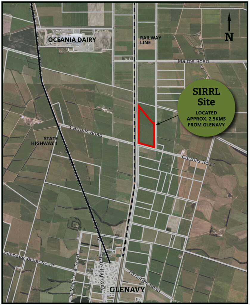
MURPHY FARMS
Murphy Farms Limited currently owns the 14.85 hectare farmland site.
Farmer and landowner Bruce Murphy said Murphy Farms agreed to sell the land to SIRRL because they do not believe landfills are a sustainable long-term option for waste disposal. He said the proposed facility would provide a reliable power source to heat the glasshouses they are considering building on their land.
“Glasshouses need large amounts of energy and CO2, which can be provided by the new plant.
This will allow us to diversify our production and potentially create up to another 200 jobs in food production.” Murphy told Timaru Herald Stuff reporter Yashas Srinivasa.
With SIRRL saying that they will provide up to 100 jobs and Murphy claiming another 200 jobs, WWW questions where these 300 employees are going to come from? Employers within the district are struggling to fill positions currently available. There is also a shortage of housing in Waimate. Oceania Dairy Factory currently buses a large percentage of its workforce from outside of the district. If employees need to be bused to and from the site from outside the district, they are unlikely to shop in Waimate, purchase fuel in Waimate, or pay rates in Waimate. How does that benefit Waimate?
MGI IRRIGATION AND A RAIL SIDING
Morven Glenavy Ikawai Irrigation Limited (MGI) owns the land between the main trunk railway line and the proposed site. This land is used to carry water via an open irrigation race that runs the entire length of the proposed site.
SIRRL submitted letters of support from MGI Irrigation and Bruce Murphy, a director of MGI, as part of its technical overview report in its resource consent application.
SIRRL has stated that future plans involves freighting upto 50% of the waste required to fuel the plant, to the site via rail; this includes the building of a substantial rail siding on MGI land.
The supporting letter, states that MGI will provide land by way of a commercial lease, for SIRRL to build a rail siding. However,
MGI claim they did not agreed on the letter and requested SIRRL retract it from their application.
Any rail siding would need to be built over the existing irrigation channel on land not owned by SIRRL. This would require a huge investment by the company, which Why Waste Waimate believes it is not likely.
Fonterra and Oceania dairy factories claimed they would build rail sidings as part of their proposals, it never happened.
An extra 134 daily truck and trailer movements on already poor-quality roads is not a popular prospect for locals; how do you counter that? Suggest rail.
A supporting letter from MGI showing that SIRRL intends to build a rail siding would also benefit SIRRL’s resource consent and Overseas Investment Office applications.
It is important to note that SIRRL’s proposal is not reliant on a rail siding; the company has stated that it intends to follow through on the proposal regardless. It is also worth mentioning that SIRRL’s New Zealand shareholder, Renew Energy, has shareholders who are involved in road freight.
FLOODZONE
The chosen site is within a flood zone, as evident in the Waimate District Plan map below. The Morven/Glenavy area sits between two large river networks, the braided Waitaki and the Waihao. The Carroll’s Road site is known to flood, with locals reporting the area flooding multiple times over the last 30 years.
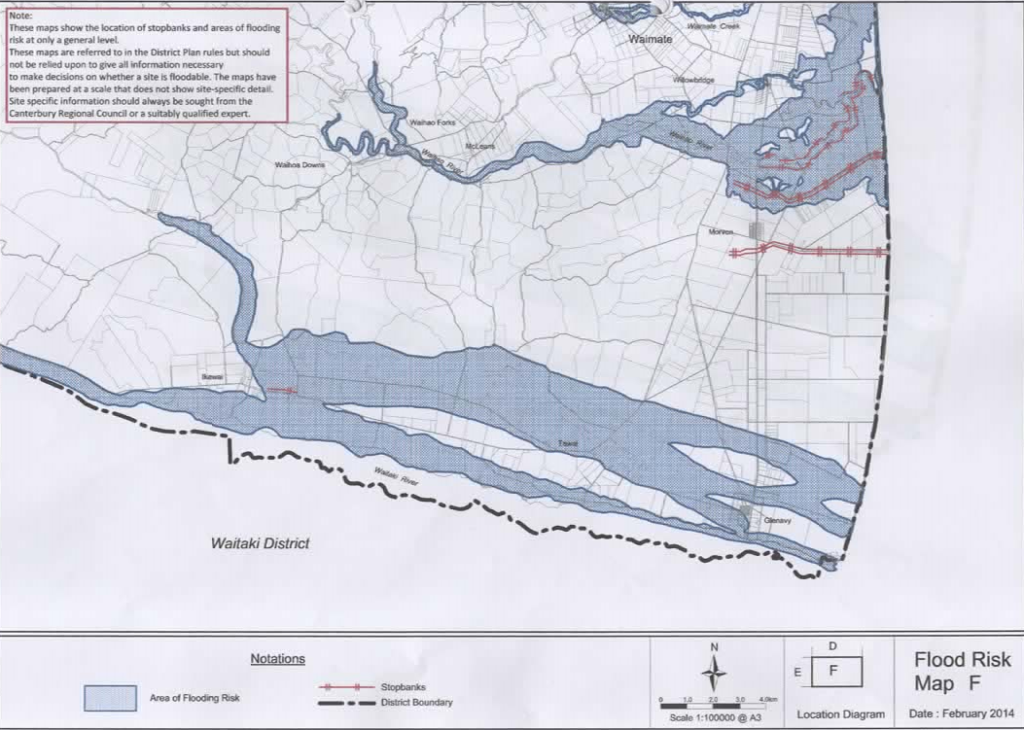

The above images sourced from The Waimate District Plan show the proposed location sited within a flood zone
WAIHAO RIVER
The Waihao River floodplain management strategy was drawn up in 2004. This strategy plan outlines the river’s long history of flooding, with 18 major floods recorded from 1902 to 1994. The following text is taken from that strategy plan.
‘Over the last 15–20 years, there has been an increasing realisation worldwide that full reliance on structural measures, such as stopbanks, to prevent flood damages is unrealistic and not cost-effective. Inevitably, structural protection measures are overwhelmed by not only greater-than-designed flood events but also smaller floods due to erosion. Additionally, complete reliance on structural protection provides a false sense of security and encourages further development on the floodplain. This increases the potential for flood damage.’
While flooding from the Waihao river may not directly effect the proposed site, such events do threaten the surrounding roading network and could therefore hinder the ability for SIRRL to transport waste and ash to and from site.
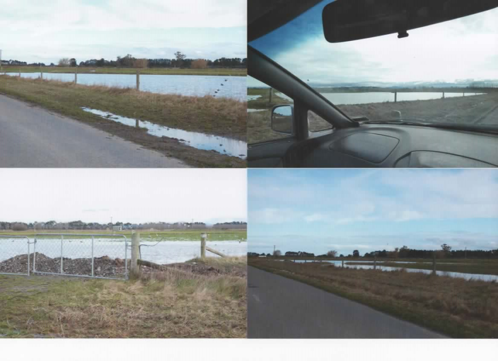
JULY 2022 SITE FLOODING
The images below show most of the Carroll’s road site under substantial water following a significant rain event in July 2022.
WHITNEY'S CREEK
The entire northern boundary of the proposed site borders Whitney’s Creek, which is also prone to flooding as it carries groundwater runoff from neighbouring properties. The MGI irrigation channel also runs the entire east side of the boundary, making the site more than 50% surrounded by water courses. In addition, there is a drainage channel that runs through the centre of the site, the company’s resource consent application states that the applicant will redirect this channel.
SIRRL has stated they will raise the site’s ground level to comply with the Waimate District Plan, allowing for a 1 in 500-year event flood levels. Climate change is making flooding more frequent, so building a plant of this scale in a flood zone can be problematic.
When the Carroll’s road land was offered for sale, it was yet to be subdivided from a much larger land title. The land offered for sale was almost 20 hectares, and included ground on both sides of Whitneys Creek.
Following the conclusion of the deadline treaty sale process, the Murphys applied to Waimate Distric Council to subdivide the land into three parcels: lot one, 14.85 hectares, lot two, 4.92 hectares, and a third allotment of 17m2 to be vested to Waimate District Council for roading.
While one could speculate on what the additional 4.92 hectares may be used for, the original listing clearly shows that the land is no longer subject to Murphy’s requirements.
If SIRRL does have a further purchase agreement with Murphy’s for the remaining 4.85 hectares, the land size is below the 5 hectare threshold, so it does not require OIO approval for overseas entities to purchase.
Native Mudfish
Whitney’s Creek is home to the threatened (Nationally Critical) and protected Canterbury mudfish (Neochanna burrowsius). Having Whitney’s Creek running through the site for the proposed incinerator could hinder SIRRL’s resource consent application and perhaps its OIO consent. The construction and operation of the incinerator could potentially disrupt the habitat of these protected species, leading to regulatory and environmental concerns. This could explain why the land purchase agreement with SIRRL differs from the original parcel of land offered for sale.
CONCLUSION.
- SIRRL claims that the Waimate district was chosen because its central location was beneficial for sourcing and transporting waste; however, SIRRL’s resource consent application shows the company will need to transport 71% of the waste required from mainly Christchurch.
- SIRRL claim that the Carroll’s road site was chosen for its proximity to the main trunk railway line and neighbouring industry; however, the company has no agreements with Kiwirail or Oceania Dairy, the only neighbouring industry in the area.
- The site is located within a flood zone. Building within a flood zone is outside the Waimate District plan and is, therefore, regarded as a discretionary activity requiring resource consent.
- The site is located within 32 metres of high-voltage power lines. SIRRL’s resource consent states that the exhaust stack (chimney) will be 75m high.
- The site is located in a rural zone. The plant will be required to store numerous hazardous substances in bulk on-site, including 100,000 litres of diesel, within a flood zone. Again, this activity is outside of the district plan.
- The site is bordered on both sides by open water courses, including Whitney’s Creek, which is home to the threatened (Nationally Critical) and protected Canterbury mudfish (Neochanna burrowsius)
- The site is within 2.5 km of a township and school, prevailing northeast winds will carry and spread emissions directly over the town and school, potentially posing a health risk to the local community.